My memory map: Spring Branch, Texas
Since satellite photos were added to Google Maps a few days ago, a lot of bloggers are showing ‘memory maps’: satellite photos of places they’ve lived. Here’s my contribution.
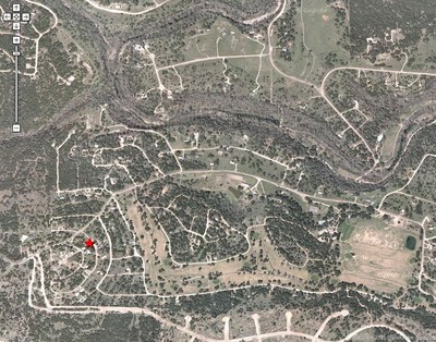
In 1970, when I was eight years old, we moved from Wichita, Kansas, to Spring Branch, Texas, north of San Antonio in the Texas hill country. We moved to Cypress Lake Gardens, a subdivision that had been started in the mid-1960s and was planned as a high-class resort with golf course, airstrip, etc. When we moved in, few houses had been built, the golf course was unfinished, and the streets were all still caliche (dirt). A year or so later, the developer was murdered, so the subdivision went into bankruptcy and receivership. Consequently, it remained in pretty much the same state until I left in 1982.
It was a pretty lonely place to grow up. Since I traveled twenty miles to elementary and middle schools and eleven miles to high school, I saw most of my friends only at school–at least until I got a car and a driver’s license.
On the other hand, my playground consisted of thousands of acres of undeveloped Texas Hill Country. The satellite photo shows a creek running through the area. This is Rebecca Creek, which features clear springs, incredible remote canyons to explore and one of the greatest swimming holes I’ve ever seen.
Differences between then and now: there are about twice as many houses now–though it’s still pretty sparsely developed–and the golf course was finished and opened a few years ago. The side streets of my old subdivision are still caliche. That big road with several cul-de-sac streets coming off of if at the bottom of the image looks like a new subdivision (looks like the streets were still being developed when the satellite photo was taken).
I identified our former house with a star. Click on the image below to see a larger version (Warning: it’s big: 375KB):