
 I had to take a different route to work this morning, down I-35 from Round Rock to downtown Austin. Every few miles along I-35 there are light-up signs that are sometimes used for Amber alerts and senior alerts. Most of the time, however, they report “Travel Time to” the next major crossroad. As I pass these signs, the QA engineer in me tries to answer the following questions:
- What is the purpose of these signs?
- What am I, a passing driver, supposed to do with this information?
- How well do the signs serve their presumed purpose?
I assume that the purpose of these signs is to give drivers an idea of how congested the roadway is at the present time. As for what I can do with this information? The sign doesn’t give any recommendations, but I assume that if the travel time is short, I could choose to stay on the road, and if it’s longer, I could choose an alternate route or just say f**k it, I’m heading back home.
The most interesting question to me, though, is how well the signs serve their purpose. In order to make a driving decision based on the information on the sign, I would have to have some idea of the following:
- Which crossroad does the sign refer to (I’ll come back to this one)?
- What does the current number of minutes shown say about the expected traffic volume? Making this judgment means I would need to know some of the following:
- How far is it to the crossroad?
- What would be a ‘normal’ travel time?
- By ‘normal,’ am I thinking of traveling the speed limit without congestion slowing me down, or what I might consider ‘normal’ for this day and time, morning rush hour in my case this morning?
- How does the current estimated travel time compare to ‘normal’?
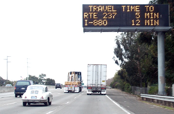
The first sign that I saw this morning, and the one that inspired me to write this blog post is installed around Pflugerville, just south of the Louis Henna/SH-45 intersection with I-35, I think. This morning, it read:
TRAVEL TIME TO
FM 734
7-9 MINS
I would argue that this particular sign fails its intended purpose by the simple fact that it refers to a road number that nobody in the Austin area uses. If you asked me which roadway in the Austin area is FM 734, I probably wouldn’t be able to tell you, but from the location of the sign and from having lived in north Austin for 20 years, I deduce/remember that FM 734 is the numerical designation for the roadway that EVERYONE in the Austin area knows as Parmer Ln.
But this brings up another question: who is the intended audience for these signs? I-35 is both a major local expressway and an important interstate highway. Since I am a local resident, my initial assumption is that the information is for me, and therefore, since I believe most Austin-area residents would not know that FM 734 is Parmer Ln, my conclusion is that the information is not very useful. If the sign is intended for someone just passing through Austin, then referring to the cross road as FM 734 is probably acceptable.
But assuming that I, the passing traveler, know the crossroad, then we come to the point where all of these signs fail their assumed purpose: in order to make use of the information provided, I have to have some way to gauge the estimated travel time against some known quantity. If you asked me, for instance, how far I thought Parmer Ln is from the sign mentioned above, I’d estimate ‘a few miles’ or how long to travel there at the speed limit, I’d estimate ‘a few minutes.’ Assuming my ability to estimate distances or travel times are average, then the estimated travel time is pretty useless.
Let’s assume that my estimate of ‘a few miles’ is somewhere between 3 and 7 miles. If it’s 3 miles, then traffic must be traveling at about 30 mph, but if the distance is actually toward the longer end of my estimate, then traffic must be traveling close to the speed limit. Considering that traffic was probably traveling at 40-50 mph–right in the middle of 30-60 mph–at the time I saw the sign, then my only conclusion is that traffic must be about the same or average for that time during morning rush hour.
Conclusion
Giving the estimated drive time to a point that is a few miles away seems to be of very limited usefulness and requires the person reading the sign to have fairly accurate information about distances or usual drive times in order to make use of the information. I guess if I drove this stretch of I-35 every day and noticed the signs regularly, then I could make comparative use of the data provided. But if I were unfamiliar with Austin, then without consulting a map, this information would be completely useless. If the estimated drive time this morning had been, say 15-17 minutes, I probably would have concluded that traffic was very heavy this morning, but considering the relatively short distance from my current location to FM 734, if congestion were that heavy, then I would probably already be traveling slowly, in which case, I don’t need a sign to tell me that traffic is slow today.
Alternatives
Since these signs apparently use some sort of real-time detection of traffic density or speed, it seems to me that a more useful to give an average traffic speed, such as:
AVG TRAFFIC SPD
NEXT 5 MI
40 MPH
Honestly, I would enjoy nothing more than having someone tell me that some of my assumptions above are wrong or to explain the process behind the decision to show average travel time.